VIDEO: More thunderstorm chances for Inland Northwest

The monsoon rain and storms are still proving to be persistent this morning. A storm north of Priest Lake was severe thunderstorm warned at 4:30 a.m. and the lightning was visible from the Spokane area. While that storm is gone, locations around Wenatchee and northward are still under the risk for thunderstorms and dry lightning though about noon today - to coincide with a Red Flag Warning for that region.
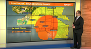
We're still not finished with storms, another batch of isolated thunderstorm are likely to develop after about 6-7 p.m. tonight across southeastern Washington or north-central Idaho. Storms will again be able to produce some hail a frequent lightning. The Storm Prediction Center places this region under a Marginal Risk for severe weather for the second straight day.
Friday's weather will be hot, with temperatures returning to the mid to upper 90s with mostly sunny skies. But the weekend will be comfortable. Highs in the upper 80s will be very enjoyable.
Next week, the heat ramps up in a big way. Temperatures are forecasted to be in the 100s mid-week with Wednesday and Thursday appearing to be the hottest days in the long-term forecast stage.
Video
More thunderstorm chances for Inland Northwest
More thunderstorms are possible for the Inland Northwest on Thursday with more hot weather on the way.