VIDEO: Record highs Monday, with cold Fall weather to arrives this weekend

We're in the final stretch of summer weather this week. The constant and crazy October warmth will be snuffed out by the weekend as Fall makes an announced return to the northwest soon.
The warm pattern is a result of a Rex-Block over the west coast. A high pressure (over Idaho) and a low pressure (over Nevada) is causing the atmosphere to be a bit stuck, leaving the warm weather in place over the Pacific Northwest.
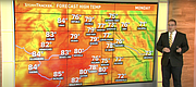
Temperatures Monday will hit the mid 70s, and for Spokane this is the best chance to hit a daily record high which stands at 75°. This will also make for the 17th day this month at or above 70 and that ties a record too.
70s last through Thursday before the Rex Block breaks down and finally a surge of cold Fall weather arrives Friday night. A strong cold front will bring widespread rainfall to the northwest and significantly colder, but closer to average, temperatures.
Highs Saturday will be in the low 50s with scattered showers and windy conditions. Sunday will be upper 40s with more scattered showers and hopefully less windy. This is about 25-30 degrees colder than today but only about 5 degrees below average temperatures.
While rain falls in the low elevations, the first mountain snow of the season is likely. Snow levels may drop to 3,500 to 4,000 feet. Peaks will definitely see snow with some higher elevation passes perhaps picking up snowfall as well.
To play off a popular saying... Brace yourselves, Autumn is Coming.
KREM 2 News is a Hagadone News network news partner. For more from our news partner, visit krem.com.
Video
Record highs possible today
Record highs are possible on Oct. 17 in the Inland Northwest but a big cooldown is on the way for the weekend.