EPA seeks public comment on repository project


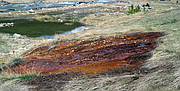
The Environmental Protection Agency (EPA) is pressing on with its plan to rebuild a repository near Canyon Creek in Burke.
Located in the same spot as the SVRNT Repository’s current location (half a mile from the Lower Burke Repository and just southeast of Gray’s Bridge), the current plan is for the EPA to move into the area, clean up, expanded, and maintain it as a repository for contaminated waste materials (as well as be cleaned up in an effort to control further contamination from the SVRNT mine dump in Canyon Creek).
This plan will triple the size of the repository for containment purposes.
Originally, the SVNRT Repository was developed in 1995 and it was designed to hold roughly 610,000 loose cubic yards of mine wastes from the Canyon Creek floodplain. The property was formerly owned by Hecla, who used it as mine dump for waste that came from the Star Mine in Burke, but it was acquired by the Coeur d’Alene Trust in 2015.
The EPA’s Record of Decision calls for the seeps from the SVNRT to be piped from Canyon Creek to the Central Treatment Plant in Kellogg, but that is still years from being possible.
At the community’s request, a fence was installed around the area to keep ATV’s from riding through the property and exposing the contaminated materials beneath the layer of topsoil they had laid down.
This topsoil was placed there in an effort to cover the contaminated waste material.
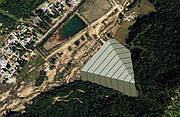
At an open house on April 5 to hear public comment on the matter, the EPA presented citizens with two options for the repository.
Option 1 entails developing the existing area to the east of the repository, an estimated 24-acre footprint. This option will require putting waste over existing groundwater spring locations and developing public access during development (which will be difficult).
Option 2 is a proposed expansion to the north of the repository, a 32-acre footprint, where no groundwater spring locations will be touched and developing a public access road will be much easier.
Both options have the capacity to hold up to 1.5 million cubic yards of waste material, but Option 2 has expansion options that would essentially double what it could hold if the time ever came that more space was required.
Maps and images of the project where also available to the public at the open house that allowed residents to see where the proposed plans will take place, while also allowing EPA representatives to dispel some of the rumors that had been floating around concerning the project.
“One of the big misconceptions out there had been that the plan is to triple the size of the Lower Burke Canyon Repository,” EPA project manager Bill Adams said. “The Lower Burke Canyon isn’t being touched as part of this.”
At this stage, the project is very similar to a remediation, but instead of a yard or a hillside, it is being done on a failing repository.
The information packet that was handed out at the open house explained why the extra space was needed.
“The nearby Lower Burke Canyon Repository does not have enough room to hold all of the cleanup waste that will be in Canyon Creek,” it reads. “Existing repositories elsewhere in the Basin not only don’t have this capacity, but if they did, it would require transport of waste through more community areas.”
Further on it read, “Expanding it (the SVNRT) will give us the needed capacity for cleanup projects within Canyon Creek, without creating an additional repository elsewhere in the Basin. The new repository will shorten haul distances, speed up cleanup, and help avoid transport of waste through multiple residential communities.”
One of the main points of contention in the past with the Lower Burke Canyon Repository has been the use of Highway 4 by the haul trucks, and the continuous traffic during their months of operation.
“There were some complaints about the truck traffic,” Adams said. “The complaints ranged from frequency of use, drivers not following the speed limit, and the operation of older trucks with diesel emissions, but we addressed some of these issues by installing a radar sign and making sure the drivers that are working are aware of the speed limit. We also work hard to make sure that all of the trucks are meeting current emission standards.”
Another part of the effort to comply with the community and their wishes to keep the trucks off the road when hauling contaminates is the proposed idea of constructing a road from the Lower Burke Canyon Repository to SVNRT Repository which would keep most of the contaminated material isolated to the specific areas off of roads that are frequented by the general public.
The waste that is planned on being placed at the repository will consist of mine wastes, waste from other remediation projects, remedy protection wastes, institutional control program (ICP) waste, and waste from the county’s various paved road projects.
The project has several benefits that Adams pointed out.
“The long term benefit really is the cleanup of the creek, as well as the historic mining and mill sites which will lead to improved water quality,” Adams said. “The direct benefits to the community will be long-term jobs being available, the truck drivers could be making around $30 per hour. And then the benefits of a clean environment and clean, safe recreation.”
The EPA is still looking for public comments and will take them until April 21, 2017.
When commenting, remember to discuss what option you prefer and why, what haul route you prefer and why, design comfort, traffic, dust, or other concerns, property and community impact, and even what you think the new repository should be named.
For more information, contact Bonnie Arthur with the EPA at (206) 553-4072 or by email at arthur.bonnie@epa.gov.