Drone aids crews in locating fire near Killarney Lake

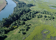
Image from Google Earth. The area snapshot indicates where the approximate area of the smoke in regard to where SCFD#2 was.

Photo courtesy of IDL. A screen shot from the video feed that was streamed live to the UAS pilot on the ground designatng the fire area. Fire Warden Truesdell stresses that having the ability to comb massive amounts of terrian with the UAS is invaluable.

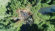
Photo courtesy of IDL. The UAS takes a closer view of the fire area as it hovers over it. Hovering the UAS in place above a problem area assists fire crews in reaching the exact location.

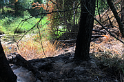
Photo courtesy of IDL. With the help of the UAS, fire crews reach the problem area and suppress the fire.
Where there’s smoke, there’s fire.
At least, that’s how the saying goes.
But what happens when you can’t pin down where exactly the smoke is coming from?
The Idaho Department of Lands had the solution on July 1 when local fire crews received reports of smoke in the area of Killarney Lake - break out the UAS (Unmanned Aerial System).
IDL reports that the search for fire began on June 24 at approximately 9 p.m. when the IDL Cataldo District Duty Officer received a mutual aid request from Mark Aamodt, Shoshone County Fire District #2 (SCFD #2) Fire Chief.
SCDF #2 was told that smoke could be seen from Highway 3, South of Killarney Lake.
Responding to the call, Truesdell, rendezvous with Aamodt near the area where the smoke had been reported.
A rough estimate was established of where the fire was as the last bits of daylight crept away.
The fire fighting collaborative attempted to find the exact location of the fire, but with the sunlight gone and several campfires burning along the Coeur d’Alene River and Killarney Lake, crews cleared the area unable to locate it.
It was then determined by the Cataldo Duty Officer that no further resources were to be committed to the search until there was another call based upon location, current fuels, and weather conditions.
Then on July 1, the Duty Officer had a discussion with a landowner that said he had seen smoke in the area several times in the past week.
He also said that he initially did not report the smoke because it could have come from a campfire, due to the intermittent showing of smoke.
Upon another patrol of the area and no smoke sighted, the Duty Officer decided that he would use a UAS to locate the fire.
Since the suspected fire area was on the other side of the river and would require crossing large amounts of marshland, the consumer level UAS (on loan from the Southern Idaho Timber Protective Association) on hand was well suited for this type of reconnaissance.
After approximately 14 minutes of flying, the pilot was able to identify the smokeless, small, black spot of the fire in the middle of mature cottonwood trees and chest high grass.
An exact location was marked and ground resources were able to view the aerial footage to formulate the most efficient plan of attack.
Four firefighters then used a boat to access the fire and spent around two hours mopping up deep pockets of heat before the fire was considered contained.
Truesdell was proud of the effort put forward by all of those who worked to locate and extinguish the elusive hot spot before it became a bigger problem.
With the aid of the UAS, the end result in this situation is what fire crews shoot for every time a fire occurs.