USFS continues prescribed burns throughout Shoshone County
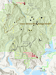
SMELTERVILLE – If residents in the area of Rose Lake, Medimont, Osburn/Wallace, Murray or Calder see some smoke coming from the woods- there is most likely no reason to be alarmed. The United State Forest Service recently announced that crews will be preforming several controlled wildland burning operations in the Coeur d’Alene and St. Joe River Ranger Districts to reduce potential wildfire impacts, prepare areas for tree planting and improve wildlife forage.
Many of these burning operations in and around Shoshone County have already begun and are slated to continue throughout the week. Some may even continue through spring going into June (others even kicking back up in October/September).
The list of operations affecting Shoshone County/Silver Valley residents are as follows:
• Fern Hardy prescribed fire (north of Rose Lake/ Cataldo)
Status: Active as of May 3. Slated to run throughout the week of May 6.
Size: 120 acres
Type: Hand ignition
Location: Mason Creek, Hayden Gulch, Hardy Gulch, Rantenan Creek, Bentley Creek and Curran Creek drainages withing 2 miles of the interstate.
• Red Beauty prescribed fire (northwest of Medimont)
Status: Active as of May 3. Slated to run throughout the week of May 6.
Size: 125 acres
Type: Hand ignition
Location: Beauty Creek drainage. Burn units are near Swan saddle off FS road 614 and FS road 1575, south of Mineral ridge.
• Ninemile prescribed burn (north of Wallace)
Status: Active as of May 3. Slated to run throughout the week of May 6.
Size: 30 acres
Type: Hand ignition
Location: North of Wallace. The best access is up Burke Road (SH 4) north 4 miles from the town of Wallace and on the west.
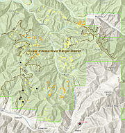
• White Beaver and Prichard/Murray prescribed burns (north of Osburn, southwest of Murray)
Status: Not active. Both slated for spring (April-June) 2019.
White Beaver location: Beaver Creek drainage including the sub-drainages of Scott Gulch, White Creek, Alder Creek, Deer Creek, Dudley Creek and Ferguson Creek.
Prichard/ Murray location: Area north of FS road 151 and south of Kings Pass road near Duncan Gulch.
• St. Joe Divide RX and Avery Watershed prescribed burns (North of Avery and Calder)
Status: Active as of May 3. Slated to run throughout the week of May 6.
Size: +800 acres
Type: Aerial ignitions
Location: North of the St. Joe River in the Big Creek, Slate Creek, and North Fork drainages. They are primarily brush fields on south-facing slopes.
USFS asks that individuals avoid burn areas due to hazardous conditions such rapid and unpredictable flame spread, falling snags and trees, heavy smoke and limited visibility, and rolling rocks and logs.
Smoke may be visible in the area for several days after the burning phase of the prescribed fire is completed. The Forest Service will monitor the fires until they are completely out.
Ignition of the prescribed fires will cease if there is a change in burning conditions and management objectives are not being met.
For more information on these projects, visit www.northidahorxfire.com for schedule and specific locations.
If you are particularly sensitive to smoke, or would like to be notified each day of the burn, please contact Luke Smith at 208-783-2102 or visit the USFS office at 173 Commerce Drive, Smelterville, ID 83868.
The Coeur d’Alene River Ranger District office phone number is 208-783-2363 and office hours are Monday-Friday, 7:30 a.m. to 4:00 p.m.
The News-Press will report further operations in the future if they arise.


