Stateline Complex Wildfire update for Aug. 1


Acres: 5,716 acres
Personnel: 369
Cause: Lightning
Containment: 0%
Start Date: Wednesday, July 7, 2021
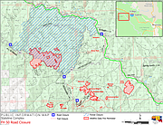
Location: All Fires are SW of St. Regis, Tumbledown ⁓16.5 miles; Dolly Fire ⁓12.5 miles; Simmons Ridge Fires ⁓15.5; Fly 3 ⁓20 miles.
Fuels: Mixed conifer
Announcement: A spot fire was observed west of the Tumbledown Fire on Saturday afternoon and fires remained very active overnight. Highway 50 between the east fork of Gold Creek and Eagle Creek remains temporarily closed due to increased fire activity. Additionally, today is the final operational shift for the Southwest Area Incident Management Team 5. The team will transfer command of the Stateline Complex incident to the Northern Rockies Incident Management Team 2 on August 2, 2021 at 0600/MT. Information will continue to be available on the Stateline Complex Inciweb page (link below).
Overview: The Stateline Complex showed active fire behavior on Saturday, July 31, with a spot fire observed on the west side of Tumbledown Fire. All other fires continued to show moderate to increasing fire behavior throughout the day and overnight. Today, crews will continue to monitor fire activity and complete structure protection efforts on threatened U.S. Forest Service infrastructure. There was no infrared (IR) flight last night over the fire, expect acreage updates from the incoming team. As of yesterday, Saturday July 31, the Stateline Complex includes the following fires: Berge Peak - contained, Broadaxe - contained, Deception – 203 acres; Dolly Creek – 825 acres Fly 3 Fire – 137 acres; Fly Creek – 52 acres; Simmons Ridge – 138 acres; Simmons Ridge 2 – 384 acres; Simmons Leg – 91 acres; Swimming Bear – 36 acres; Tumbledown – 3,844 acres; Wampus Creek – 6.2 acres.
Fire Update: Fire behavior for all fires within the Stateline Complex were active overnight and will continue to be active until the afternoon today, as fire is anticipated to continue spreading in heavy dead and down fuels as well as north slopes and live fuels. Later in the day, fire behavior will decrease as moisture arrives. Over the next 24 hours, cloudy conditions and forecasted precipitation will assist in slowing the drying of fuels and moderating fire behavior.
Weather: Saturday was a critical fire weather day across the Stateline Complex, with temperatures ~15 degrees above normal, relative humidity (RH) values in the teens and ridge top winds gusting over 20 mph. The Complex will experience much cooler and wetter conditions on Sunday with showers and scattered thunderstorms in the afternoon. Gusty outflow winds and lightning are anticipated, with a 70% chance of wetting rains. Communities are encouraged to stay apprised of shifting weather and flash flood watches/warnings.
Smoke: Today communities around Superior, St Regis and Plains will likely see 'Moderate' to 'Unhealthy for Sensitive Groups'. In Thompson Falls, Avery and Calder air quality is likely to decline into 'Unhealthy for Sensitive Groups' to 'Unhealthy' levels due to the large fire activity and growth yesterday. Polson should remain 'Moderate'. With tomorrow’s cooler temperatures and expected rain, a slight improvement in air quality is expected for Monday.
Closures: On Tuesday, July 27, Shoshone County Sherriff’s Office issued a closure expansion for Forest Highway 50 (St. Joe River Road) from Quartz Creek down to Eagle Creek forest road 1214 to the Stateline on Golds Pass into Montana. Several other emergency closures remain in effect due to increased fire activity on the Stateline Complex. Access to Diamond and Cliff Lakes remains closed as well as the following roads and trails: Diamond Lake Road #7843, from milepost 0.00 at junction with Dry Creek Road #342 to the end of the road; Diamond Lake Trail #56, from milepost 0.00 at junction with Diamond Lake Road #7843 to the end of the trail; Cliff Lake Trail #100, from milepost 0.00 at junction with Diamond Lake Road #7843 to the end of the trail; and Dry Creek Divide Trail #203, from milepost 11.94 at junction with Dry Creek Road #342 to the end of the trail.
Additionally, a temporary flight restriction remains in place for the entirety of the Stateline Complex area and several other areas remain closed, including Quartz Creek as well as the following: FSR 1216 from its junction at Highway 218 to its terminus; Gold Flat Campsite (T16N, R30W, Section 23); several trails and areas within the St. Joe Ranger District. The latest information is available at the links below. All closure information will continue to be available on the Stateline Complex Inciweb page (link below). Dry Creek Road #342 remains open for motorized use.
Restrictions: Stage II Fire Restrictions are in effect for the Idaho Panhandle (Coeur d’Alene and Grangeville dispatch areas).
Know Before You Go: The Stateline Complex and incidents to the west and across the region are anticipated to persist into the coming weeks, resulting in area closures, visible smoke, decreased air quality, and impacts to travel and recreational activities. Local community members and visitors to the towns and recreation areas within and around the Idaho Panhandle National Forests are encouraged to stay informed of the fire activity within and around the Stateline Complex. The following links provide on-going updates on fire activity, closures and restrictions, and maps.
Stateline Complex Daily Updates on Inciweb: https://inciweb.nwcg.gov/incident/7627/
Idaho Panhandle National Forests Facebook: https://www.facebook.com/USFSIPNF
Lolo National Forest: https://www.facebook.com/USFSIPNF
Idaho Fire Map: https://idfg.idaho.gov/ifwis/maps/realtime/fire/
Idaho Smoke Information: http://idsmoke.blogspot.com/
Fire Information for Idaho Hunters & Anglers: https://idfg.idaho.gov/fire
Fire Restriction Information: http://www.idahofireinfo.com/ and https://www.mtfireinfo.org/
Area Closure Information: https://www.fs.usda.gov/alerts/ipnf/alerts-notices.