Deceitful Wildfire update for Aug. 17


Critical fire behavior occurred late Monday evening, which spurred multiple evacuations, road closures, and power outages.
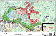
The Deceitful Fire (10,879 acres) made a 5 mile run and grew over 3,000 acres past Beaver Creek, over Kings Ridge, and down into Prichard Creek near McComber Gulch area.
As of Tuesday morning, there were no injuries that occurred and no residences lost. There has been some reported damage and loss of a small number of secondary structures or outbuildings. This success, in spite of extreme fire behavior, is due to a substantial amount of structure protection preparation (fireline, fuels reduction, sprinkler lines).
Suppression resources worked late into the night and stayed on scene overnight. Firefighter and public safety continues to be the main priority while Tuesday’s objective will be structure protection and assessment of the large growth of the wildland fire.
The Level 3, "GO" communities will remain in effect for Tuesday and residents should not return to their property. New areas have been added to the "Ready" and "Set" evacuation preparedness categories as a precautionary measure. See attached graphic on preparedness category descriptions.
Please stay tuned for more information as it becomes available.
Communities in the "READY" Category:
• North of Highway 90 (includes Old River Road) – Kingston to Steamboat at Cd’A River Road mm 13 near Castle Rock
• North Smelterville
• North Kellogg
• Montgomery- Moon
• Osburn
• Silverton
• Canyon Creek- Burke Road
Communities in the "SET" category:
• The Coal Creek Community from Cd’A River Road mile marker 13 (East of Castle Rock) to mm 18
Communities that remain in the "GO" Category:
• Cd’A River Road from mile marker 19 (Hopkins Creek) up to Shoshone Mountain Retreat & Ranch (Lutherhaven)
• Eagle, Idaho
• Murray, Idaho
• Beaver Creek, Idaho which includes from Babins Junction south to the top of Dobson Pass
• If listed above in ‘Go’, do not return to your residences or property at this time.
ROAD CLOSURES:
• Cd’A River Road and Old River Road from Steamboat Pond (11) to Shoshone Mountain Retreat & Ranch (Lutherhaven)
• Beaver Creek Road from Babins Junction south to Dobson Pass
• Kings Pass
• Prichard Creek Road and Thompson Pass
POWER OUTAGES:
• Power is out in all of the areas in the GO Category. Lines have been depowered by Avista for the safety of first responders and residents and will be turned back on when safe to do so. o Includes: Coal Creek, Eagle, Prichard, Murray, and Beaver Creek (north of Dobson Pass)