Deceitful Wildfire update for Aug. 18


Deceitful Wildfire quick information:
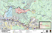
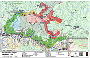
Size- 11,404 acres
Containment %- 10%
Personnel injuries- 11
Structures threatened- 160
Structures damaged/lost- 2
Total personnel- 271
Summary: Yesterday saw wetting rains on the Deceitful Fire which helped decrease fire behavior. Tuesday operations were focused on cooling hotspots within the fire interior and assessing structures within the evacuated areas of North Fork Coeur d’Alene River, Beaver Creek, Eagle, Prichard and Murray.
As of Tuesday evening, no residences were lost. However, there was minimal damage and loss of a small number of secondary structures or outbuildings. Substantial structure protection preparation, such as fuels reduction and sprinklers, helped mitigate the loss of homes.
The top priority on Wednesday is structure protection and getting power back as soon as possible. Crews will also work on building fire lines along the southern portion of the fire near Beaver Creek and the King’s Pass area. Heavy equipment crews will be identifying where a dozer line could go near Murray. The Level 3, "GO" evacuation that was implemented Monday is still in effect and residents in those areas should not return to their property. New areas have been added to the "Ready" and "Set" evacuation preparedness categories as a precautionary measure as of August 17, 2021.
For more evacuation information, call the Sheriff’s office at 208-556-1114 or go to the Character Complex evacuation and closure page on Inciweb: https://tinyurl.com/xwnuyc5b
Weather and Smoke: Wednesday cloud cover will be decreasing throughout the day with a small chance of precipitation in the late afternoon. Temperatures will range to the upper 60s and low 70s and humidity will decrease to 45%.
Air quality for the area will be Moderate. For more information on air quality, please visit https://fire.airnow.gov/
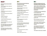
Communities in the "READY" Category:
• North of Highway 90 (includes Old River Road) – Kingston to Steamboat at Cd’A River Road mm 13 near Castle Rock
• North Smelterville
• North Kellogg
• Montgomery- Moon
• Osburn
• Silverton
• Canyon Creek- Burke Road
Communities in the "SET" category:
• The Coal Creek Community from Cd’A River Road mile marker 13 (East of Castle Rock) to mm 18
Communities that remain in the "GO" Category:
• Cd’A River Road from mile marker 19 (Hopkins Creek) up to Shoshone Mountain Retreat & Ranch (Lutherhaven)
• Eagle, Idaho
• Murray, Idaho
• Beaver Creek, Idaho which includes from Babins Junction south to the top of Dobson Pass
ROAD CLOSURES:
• Cd’A River Road and Old River Road from Steamboat Pond (MP 11) to Shoshone Mountain Retreat & Ranch (Lutherhaven)
• Beaver Creek Road from Babins Junction south to Dobson Pass
• Kings Pass
• Prichard Creek Road and Thompson Pass
POWER OUTAGES:
• Power is out in all of the areas in the GO Category. Lines have been depowered by Avista for the safety of first responders and residents and will be turned back on when safe to do so. Includes: Coal Creek, Eagle, Prichard, Murray, and Beaver Creek (north of Dobson Pass).