Second winter brings snow and low temperatures

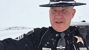
An Idaho State Police trooper responds to the top of Fourth of July Pass on Sunday for one of many slide outs that were reported that day.
Photo by SHANELL HUGGINS

Idaho State Police Sgt. Justin Klitch warns North Idaho motorists of hazardous driving conditions via Twitter Monday morning.

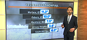
KREM 2 Meteorologist Jeremy LaGoo talks about high snowfall totals Monday morning.
It appears that the latest winter storm to hit North Idaho took many by surprise, as emergency crews across the panhandle responded to numerous weather related incidents between Sunday night and Monday morning.
Idaho State Police District 1 Dispatch reported that as of 1 p.m. Monday, their office alone had received approximately 50 weather related calls in which a trooper responded and provided assistance. Many of these calls came in when the storm first hit the region Sunday night and caused numerous incidents on the local mountain passes.
By 6 that night, chain-up laws had been activated on both Fourth of July and Lookout Passes, but the closures came anyway.
“The Idaho State Police are in the area of 4th of July Pass, both directions, with multiple spun out semi trucks completely blocking I90,” ISP reported Sunday night via Twitter. “The Chain Up Law has been activated by ITD. Please avoid the area and drive safely.”
Not long after, motorists on Lookout also saw delays.
“The storm moved east and has hit Lookout Pass,” ISP tweeted. “The Idaho State Police are on scene of 7-8 spun out or jackknifed semis completely blocking the eastbound lanes on I90 at milepost 70. The Chain Up Law for Lookout Pass is activated by ITD.”
No major injuries were reported from these incidents.
According to KREM 2 News Meteorologist Jeremy LaGoo, the Silver Valley saw some of the biggest snow accumulation totals in the region with Wallace reporting 11.3 inches of snow with even more hitting the areas of Mullan and Lookout Pass.
Weather conditions became so intense that by Monday morning, ISP Sgt. Justin Klitch took to social media to issue a warning to those driving in North Idaho.
“Just wanted to give a warning, if you can, stay home,” he said on Twitter. “If you have to travel, use extreme caution. The roads are completely snow and ice covered. (On) Interstate-90 and US-95, we have several crashes. Some areas are white-out, blizzard-like conditions. It’s very difficult to see.”
This latest short blizzard will kick off some of the lowest temperatures of this winter season.
Overnight lows will drop into the single digits with daytime highs near 20 degrees. That's colder than even our average coldest January day, and it doesn't count the wind.
Wind chills in the coming days will drop to 0 to 15 degrees below zero in the days to come.
For that reason, wind chill advisories are in place from 9 p.m. Monday through 10 a.m. Wednesday. Wind gusting at 30 to 40 miles per hour will have the potential to cause frostbite or hypothermia in as little as 30 minutes.
The worst of it will come to an end on Wednesday. Clouds will filter back in as temperatures rise heading into the weekend.
KREM 2 News is a Hagadone News Network news partner. For more from our partners, visit krem.com.