VIDEO: Major wind storm in store for the Inland Northwest this Friday

A multi-faceted and powerful storm system will hit the Pacific Northwest by this Friday. With a variety of possible impacts, the most important for Spokane and the Inland Northwest appears to be the high winds.
The weather setup leading into this Friday is driven by a powerful conveyer belt in the jet stream over the North Pacific. This is similar to an atmospheric river and will feature many of the same properties, with the only major difference being that the draw of moisture isn't directly from the tropics. Nonetheless, this flow of deep moisture will hit Washington state Thursday night and last through Friday and Saturday.
HIGH WINDS
A High Wind Watch has been issued for a majority of the Inland Northwest from Friday afternoon to Saturday morning. Wind gusts up to 60 mph are possible which would cause power outages and tree damage.
The strong winds will have the largest impact on the region and are the priority of the forecast. Southwesterly winds will start to increase Friday morning to 30mph and continue to accelerate up to 45-60mph by Friday evening, during the peak of the storm.
Should wind gusts be close to 60mph, that is considered more severe and violent. Wind Advisories and High Wind Warnings will likely be issued by the National Weather Service in Spokane by Thursday evening before the event begins.
Wind gusts on Saturday will begin around 50mph but decrease back to 30-40mph during the day.
SNOW
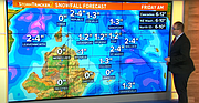
Wet and slushy snow will likely fall Thursday evening and Friday morning. Temperatures will hover around 32-35°, meaning this is going to be a wet and slushy snowfall. This probably sticks to the grass and elevated surfaces more than the roads. Still - this will likely make for the first official snowfall of the season!
Spokane will get around 1" of this wet-and-slushy snowfall. Up to 2" of this snow is possible for North Idaho and northeastern Washington locations.
Any snow that falls by Friday morning will melt during the afternoon. Highs on Friday will be near 50° as the mild moisture conveyer belt warms the air during the day.
RAIN
As the snow changes to rain, the rain will be heaviest and most consistent on the windward side of the mountains and foothills. With that being said, North Idaho and a portion of northern Washington will see the most rain, upwards of 1", during this event. Spokane is expecting about 0.3 - 0.5" of rain.
The Cascades will surely set up a decent rain-shadow effect for central Washington and the Columbia Basin. But it won't be perfect as plenty of deep atmospheric moisture is available. The Seattle area and western Washington are forecast to get 1-3" of rain with even higher precipitation amounts along the Cascades - with some of that falling as both rain and snow, depending on the snow level elevation.
AFTERWARDS
Not covered as extensively, but a separate storm system will hit the PNW Sunday and Monday of next week. This is a strong cold front from the Arctic and Alaska. Far colder temperatures will mean that a chance for snow is likely Sunday and very likely Monday. But the intensity and specific snowfall totals are just a shot in the dark at this stage of the forecast.
KREM 2 News is a Hagadone News Network partner. for more from our partner, visit www.krem.com.
Video
Snow, rain, and wind on the way for North Idaho on Friday
Snow, rain, and wind on the way for Spokane, north Idaho on Friday