VIDEO: Cool & wet through the end of October

Parts of the Inland Northwest might see the first snowflakes of the season Wednesday morning, including Spokane. Don't worry, it doesn't look like any of it will stick below 3,000 feet. So, if you haven't seen snow on the ground yet, you don't have to worry.
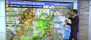
The next weather maker for the region is moving into the Northwest. An incoming cold front and storm will sweep the region Tuesday night and early Wednesday morning. Another 0.1 or 0.25" of rain will fall in low elevations with a couple inches of snow possible up high (the mountains).
Cold temperatures Wednesday morning mean we might get lucky enough to see a few more snowflakes fly, but don't expect anything to stick just yet. Most of the snow stays above 3,000' again Wednesday morning. Higher elevations have the potential to pick up a few more inches of snow by the time it all comes to an end Wednesday afternoon.
As the storm moves out, there's a quick break in the action. A ridge of high pressure that builds Thursday offers a little sun and a break from the rain before a more active weather pattern returns this weekend.
KREM 2 News is a Hagadone News Network partner. For more from our partner, visit krem.com
Video
Rain, cooler temperatures and cloudy skies ahead