Report sheds light on deadly avalanche

The yellow line indicates the intended route for the three backcountry skiers prior to the avalanche near Stevens Peak. The orange route illustrates their actual route. The red mark indicates the site where the body was recovered after the avalanche.
Photo courtesy of Idaho Panhandle Avalanche Center

A photo taken from the helicopter on January 12 shows an aerial view of the avalanche area by Stevens Peak.
The Idaho Panhandle Avalanche Center released its report Tuesday concerning the Jan. 11 avalanche that stranded two skiers and left another skier dead near Stevens Peak.
Landon E. Crecelius, David R. Sittser and Corey J. Zalewski left the Stevens Lake Winter Trailhead at 8:14 a.m., aiming to ascend into the Lone Lake drainage below Stevens Peak and ski on the east facing side of the area. The trio made plans the evening prior through a Zoom video call.
Departing from the trailhead at 3,500 feet, the group ascended the lower Lone Lake drainage to reach the west ridge, just south of West Willow Peak at an elevation of 6,302 feet.
At 12:14 p.m., the party descended by ridge on the east-facing slope adjacent to their track. Following the initial lap, they continued up the ridge to the south, intending to ski further up the drainage with a similar slope angle, aspect, and elevation.
On their second descent, the skiers chose a slope with varying angles and intermittent islands of trees. Following safety protocols, they descended one at a time. The first skier, Crecelius, descended 400 vertical feet, then radioed from a presumed safe location to the second skier, Zalewski, that they were clear to start.
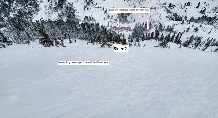
At 2 p.m. during Zalewski’s descent, a small, localized avalanche was activated, accumulating to around a foot deep. According to the report, “The avalanche fully buried skiers one (Crecelius) and two (Zalewski) with skier three (Sittser) witnessing the event from above and promptly initiating a search."
Using a beacon search, Sittser located Zalewski by the tree line, thanks to a deployed airbag visible on the surface. Sittser dug around the airbag and found Zalewski’s body pinned against a tree with no signs of life. A helicopter recovered his body the next day.
Crecelius was carried by the slide and buried. After managing to extricate himself, he determined the had a broken forearm.
Crecelius and Sittser were able to communicate verbally, and at 2:18 p.m., they sent an SOS message using a Garmin InReach which was relayed to the Shoshone County Sheriff’s office and the Shoshone County Search and Rescue team. The men attempted to build a shelter to get warm but decided to move toward the trailhead instead because of the frigid temperatures
Crecelius had lost his skis and poles during the avalanche, which added time to their trek along with the changed landscape.
IPAC investigation
Due to dangerously cold weather the two days following the avalanche, IPAC personnel were not able to visit the site until Jan. 14. Jeff Thompson, Ben Bernall, Mikey Church and Izzy Davis conducted the investigation of the avalanche fatality.
The IPAC report stresses that the avalanche timeline was compiled with full cooperation from the accident survivors. The report's purpose is to help educate the community about safety measures and share professional conclusions about the incident.
On the day of the fatality, snow totals from a nearby weather station at Silver Mountain recorded 29.7 inches of new snow since Jan. 3.
In a section where IPAC discusses the “hard truths” of honest assessment, the report says that while the party was well-prepared and did many things right, “they underestimated the destructive power of a potential avalanche.”
The skiers attempted to mitigate the risk of disturbing the snow by traveling one at a time to safety zones, they had avalanche safety gear with them and had recently practiced with their beacons.
While signs of potential danger weren’t present to the naked eye, storm forecasts, windy conditions and reports of recent avalanches were background indicators of potential snow instability in the area, according to the IPAC report.
Due to obscuring weather conditions, the group adapted their original plans into more difficult terrain.
All three skiers in the party were experienced backcountry travelers and the Garmin InReach they carried enabled them to communicate with the outside world by text exchanges with the Garmin SOS dispatch services every 30-60 minutes, who then relayed information to first responders in the area.
Low hanging clouds, darkness and strong winds prevented helicopters from reaching the party.
IPAC’s report states that “the survivors traveled most of the way out of the mountains on their own, only meeting rescuers about a mile and half from the trailhead.”
Rescue operations
The Shoshone County Sheriff’s Office was alerted shortly after the SOS call sent out from the Garmin device. Shoshone law enforcement alerted Shoshone County and Kootenai County Search and Rescue teams, Silver Mountain Ski Patrol, and the Northern Rockies Avalanche Canine team.
Crecelius and Sittser were advised by the Shoshone County Sheriff’s office to stay where they were in hopes that a helicopter rescue could be arranged. Both Army and Fairchild Air Force teams made attempts, but were deterred by gusty winds and poor visibility.
After waiting over two hours, Crecelius and Sittser were advised to hike out. They covered more than half the distance to the trailhead when they were met by members of the Silver Mountain Ski Patrol and traveled further. Kootenai County Search and Rescue transported them out the rest of the way. An ambulance was waiting at the trailhead.
 A photo taken from the helicopter on January 12 shows an aerial view of the avalanche area by Stevens Peak.