VIDEO: Rain returns Monday

Move right in the slider for video content ->
KREM 2 News
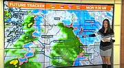
Rain returns to the area on Monday, and with off and on showers throughout the week, we could see another .25"-.50" of rainfall. Snow levels should remain at 3000 ft or higher, but some wet snowflakes wouldn't be out of the question for the higher spots around town Monday morning.
KREM 2 News
Wet weather Friday and early Saturday brought 0.40" of rain to the Spokane Airport, which had previously seen three straight weeks without measurable precipitation. A much wetter weather pattern will carry us through the end of the month, which usually sees about 1.47" of rain.
The Spokane Airport saw its first freeze of the season Sunday morning with an official low of 32°. Even though cold temperatures are expected for much of the week, clouds should keep overnight lows just above freezing.
Rain returns to the area on Monday, and with off and on showers throughout the week, we could see another .25"-.50" of rainfall. Snow levels should remain at 3000 ft or higher, but some wet snowflakes wouldn't be out of the question for the higher spots around town Monday morning. In addition to the cold temperatures, it's going to be on the breezy side Monday and Monday night, with wind gusts out of the south and southwest up to 30 mph. High temperatures will start off the week in the upper 40s, but warm into the low 50s by the end of the week.
Video
Storm bringing more rain and mountain snow to Spokane, Inland Northwest
Rain returns to the area on Monday, and with off and on showers throughout the week, we could see another .25"-.50" of rainfall. Snow levels should remain at 3000 ft or higher, but some wet snowflakes wouldn't be out of the question for the higher spots around town Monday morning.